El Cajon Mountain ©
December 27, 2011, Joel Hawk
WOW! What a hike. That hike is an ass kicker and mine is the one it kicked! This is not for the recreational hiker, small children, or Big Boys like me – unless you’ve been doing some strenuous; I mean arduous/difficult/really tough hikes to build up your endurance. This is also not for those who have bad knees or those with little or no commitment in facing a challenge and succeeding. Make sure you’ve been working on building muscle during your hikes so you can handle the “straight ups” and “straight downs” – trust me, I’m not kidding. It’s only an 11.2 mile hike, but starting right out of the trailhead, you’re climbing. Be sure to wear “good” hiking boots with a thick sole and good grip as you’ll be walking on embedded rocks, loose DG (Decomposed Granite), sand, over/through and around boulders, cross a couple of little water run-offs and if you go all the way to the top, you’ll do a little bush-whacking. The trail (loosely maintained) ends and if you want to see the Bench Mark (sometimes called a survey marker), you strike off directly through the brush using animal trails or a water run-off path that others have turned into an unofficial trail. But I get way ahead of myself….did I say this was a tough hike?
Ok, let’s reel it in a little. I actually feel fine and a sense of pride that I took on another adventure without knowing anything about what I had signed up to do and completed it. On top of that, my GPS didn’t work with the trail map I had downloaded, so all I had was my paper map and my compass. The trail/road was actually pretty easy to follow (just follow the footprints at the turns). I am comfortably exhausted; most likely some soreness tomorrow. Nothing a good massage and a couple of beers can’t fix.
The trailhead is on the corner of Blue Sky and Wildcat Canyon.

If you think you’ll be out there past 5:00 p.m., don’t park in the lot. Park along the street where it’s not posted, “No Parking.” That way, your car will be there when you come back down. There are restrooms just a few hundred yards once you leave the trailhead, but after that, you’re on your own out there. As soon as you start taking your first steps, you start climbing and you don’t stop until you come back. Really, it’s up both ways. Ok, ok, it’s up and down in a very steep manner all the way out there and back, so it feels like it’s up both ways. You’ll climb just under 4000 ft total if you stick to the trail. Walking sticks/poles are a must. You’ll be so happy to have these for the downhill to help with balance, but it’s awesome as well for the uphill because you can generate much more speed and balance going up. I call it my “Power walk.” The downhill is simply mass-in-motion so don’t get in front of me. I won’t run over you on purpose, I’m just motoring.
I’m typically a good water conservationist. But, I drank it like a mule out there and the weather was very nice. I think we were in the high 60’s per the weather-guesser. So, when folks say bring plenty of water, they mean like 2 liters or more. I packed a G-force for lunch to replenish the electrolytes once I reached the turnaround point. This is not a hike to do during the heat of the Summer – well, my recommendation anyway. Naturally, bring nibbles and lunch so when you’re sitting on the survey mark (benchmark) at the top of El Capitan, you’ll have enough energy to make it back to the trailhead. Sunscreen, hat, phone, lip balm, and a camera, and maybe binocs are other items to bring. You’ll be thankful you did.
So I parked in the lot, stretched, slammed a bottle of water, had some GORP and away I went. I started early at 7:10 a.m. and waved at the Ranger when he drove by hoping we wouldn’t have to see each other later on in the day. Climbed up the street for a couple hundred yards and put the Rangers phone number in my phone as a just in case I really needed it for any reason. It’s posted on the info board by the restrooms and it’s a good idea when you’re hiking in the back-country (well, for San Diego, this is back-country). Once all settled, I started off on my climb. Did I mention this is a steep uphill/downhill? Well, you get to test the waters right off the bat. Nice switchbacks as you climb up through the low-lying brush. When you get to the top, it’s an awesome view to the North and the West. You will overlook Barona, into Ramona, see Iron Mtn., Woodson Mtn., Black Mtn. #2, the Santee mountains and others. Back to the trail and upwards we go.

Once I reached the top of the first “little” hill, I could see my destination. Just another four peaks to go and I’ll be there (it’s way out there along this ridgeline about 4.5 miles).

One of two information placards I saw along the trail. This area was devastated by the Cedar Fire of 2003. I tried to envision how stark and barren the area would have looked after that fire. So sad and I heard it started because some fella was lost and tried to get some help. He lit the fire intentionally and over 2200 homes were lost as well as 15 lives. Here’s a link for more information. http://en.wikipedia.org/wiki/Cedar_Fire

I was walking along and as always had my head on a swivel. I looked off into the distance and saw what appears to be a missile shoot. It’s either that or a very high performance aircraft. Reminded me of a time I was sitting on the tarmac in Okinawa back in the 70’s when I saw an SR-71 take off. First time I ever saw an airplane conduct a vertical nose up climb on takeoff and kept getting faster.

As I was climbing along I saw a rock formation that struck me oddly. Reminded me of a movie I had seen once called Conan, the Barbarian. This rock really looked like a snakehead. You can see two little fangs and his eyes better when you’re there.

Did I mention this was a tough hike? Have a look at some of the trail I was on.


About the four mile mark, I saw an old jeep chassis. Not really sure how it got up there, I guess someone could have driven it up somehow or maybe it was lifted by a helicopter. Folks in the past did drive along unimaginable "roads" getting across the lands. I would not have wanted to be a rider in that vehicle after walking the trail up. Can you imagine?

Ok, I’m at my turn-around point. Phone reception was great. As I was eating lunch, I called Chris and could hear her well.

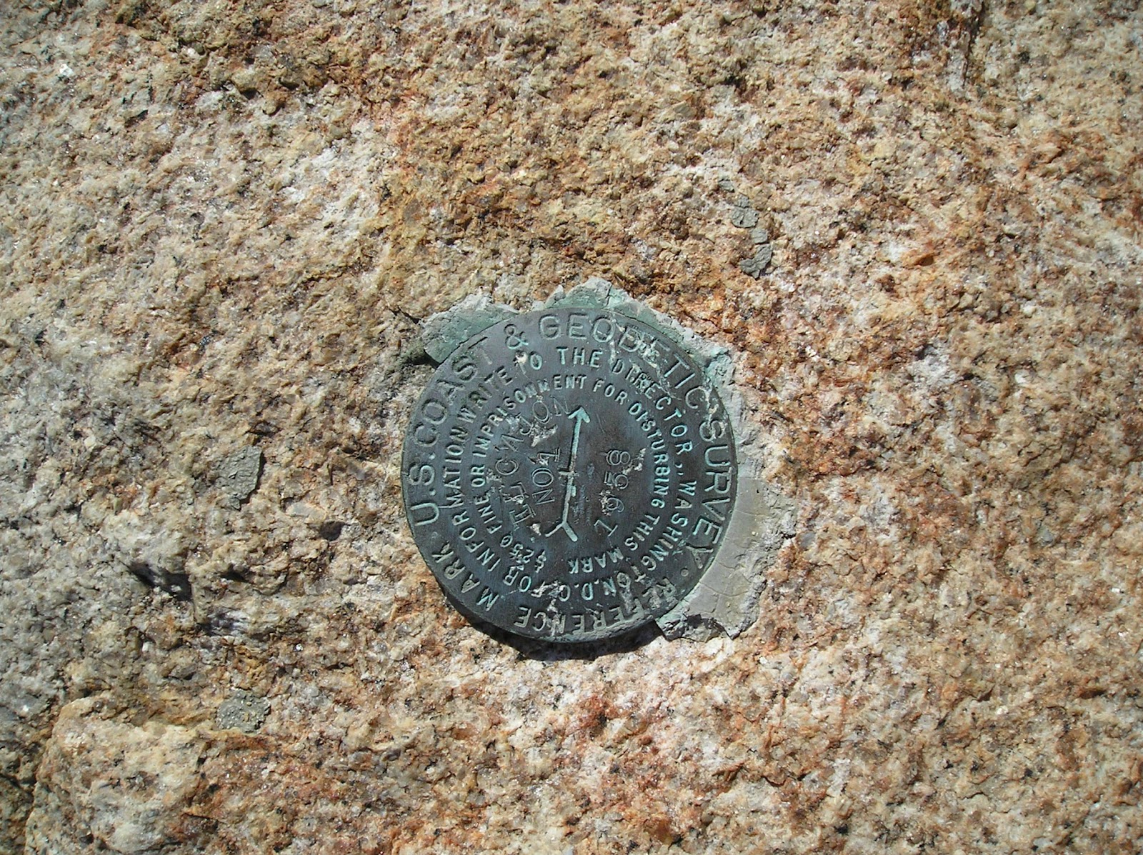
Once on top, I found two benchmarks, but only one is the true benchmark and it is identified with the triangle. The other survey marker is an azimuth marker pointing toward the "real" benchmark and you can tell by the arrow. Sure 'nuff, the benchmark was in that direction. Don't you just love to learn all this stuff?

The views cannot be explained, but they were awesome! Every which way one looked you could see for miles and miles and miles. This is the El Capitan Reservoir. I could see three different bodies of water (and the ocean of course). Yes, just a few short hours ago I was down at that level.

The return trip was uneventful, but I did see some unprepared hikers along the trail. I mean that since all I saw them carrying was a single bottle of water and wearing tennis shoes. They didn't have a map nor gps, and asked me for directions to the top. I told them what to expect, wished them well, offered some alternative hiking goals where they could still enjoy their hike and suggested that they probably only wanted to go a shorter distance on this day and come back another time to go all the way up. I thought about them as they struck off and continued on my way back to the trailhead. Worn out and beat, I sure was glad to reach the car. See you on the trails.
Be safe, enjoy living and appreciate our lands. ~ Joel
Latitude/Longitude (WGS84)
32° 54' 53'' N; 116° 49' 13'' W
32.914778, -116.820141 (Dec Deg)
516818E 3641854N Zone 11 (UTM)
32.914778, -116.820141 (Dec Deg)
516818E 3641854N Zone 11 (UTM)
No comments:
Post a Comment