I wanted to write an article about several educational things to keep you safe such as, what to do if you get lost on the trail, or how to signal for help when needed, etc. In researching this project, I came across a website that has a ton of great information already posted so thought I'd share that with you vs. writing my own article.
There is a ton of great information on the site below so again, in an effort to help keep you safe, feel free to visit and learn what you can. Be sure to come back to my site to keep up with my travels.
http://www.hikingdude.com
Tuesday, February 26, 2013
Monday, February 25, 2013
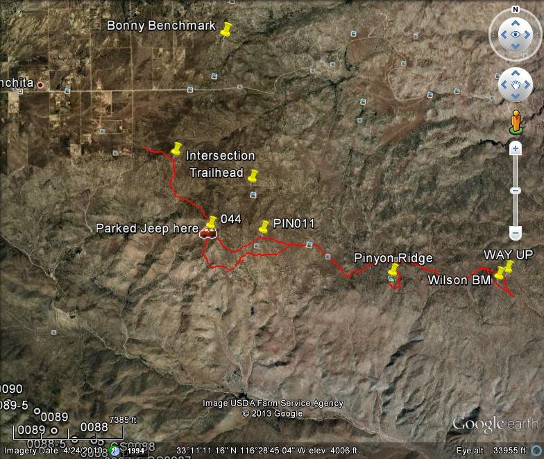
Pinyon Ridge and Wilson Benchmark
Pinyon Ridge and Wilson Benchmark©
February 23, 2013, Joel Hawk
(Click on pictures to enlarge)


Although the fires destroyed so much, there are signs of life returning to the desert. We saw signs of big horn sheep and heard a pack of coyotes howling, but never saw any of them. We did see birds, rabbits and ground squirrels. I thought I saw some deer print, but it may have been a baby sheep. Tough to tell. In this picture, Chris said we're not alone and up on the ridge to the left of the rock, it looks like two people walking. It ended up just being cacti, but it sure looked real for a while.


...When we going
......When we going???
Be safe, enjoy living and appreciate our lands. ~ Joel
Directions and the numbers:
Travel to Ranchita on Montezuma Valley Road just before dropping down the grade into Borrego Springs. Exit on Yap to the South for about .5 miles or so and turn left onto a jeep road (can't remember if there was a street sign or not, but it's called Old Wilson Road). This is in the Anza-Borrego Desert and there are lots of dirt bikes on the trails so be careful. You will come upon a circle four-way and if you wanted to add a little mileage to your hike, you could turn South on Jasper Trail here or if you want to go only around 9 miles or so, press forward on Culp Valley Road to the trailhead. Total round trip the way we went is appx 11.2 miles, 3234 total ascent with a max elevation of 4623 ft. Overall this took us about 4:45 hours.
Copyright: All Rights Reserved
Wednesday, February 20, 2013
Gasp and Groan Mountains
Gasp and Groan Mountains ©
February 9, 2013, Joel Hawk
(Click on pictures to enlarge)
Jack "Bagger" and I left early so we could be parked at sunrise. As always, best laid plans have a way of changing themselves. We initially parked where we thought we should only to find out we were about 2 miles off. We did make a note of this spot so we could come back and take on a different challenge when we plan to bag Peak 3640. But that's another story. What we did see was a fantastic ring around the moon when we first climbed out of the jeep. The picture does not do this moment in time any justice, but if you look hard enough, you can just make out a bit of the ring. (click on the picture to enlarge for better viewing)

Since we knew we were in the wrong spot, we left and made it to the correct spot just in time for this picture. God I love starting my day like this.

It strikes me as odd that no matter how much planning or forethought I put into a hike, the adventure always promises to be more than I bargained or hoped for. That's part of the excitement I look forward to while on my hikes. Learning about the local areas where we live is so much fun and if one takes the time to look around while out there walking through our lands, they could see so much. All it takes is a little imagination and a playful nature to see things differently. For example; this rock is simply some rock formation on the ridgeline that I'll bet many have walked right past and never even noticed. As soon as I saw it, a voice went off in my head that said, "I'm watching you" and naturally, I started giggling. This is another reason why I hang back and let Jack get up a few hundred yards from me. Being easily amused is a gift - or so I say.

We hadn't gone far, but I already knew I was in for a fun day. I hollered at Jack to look at the rock formation above. This rock structure is looking down over Redondo Flats. Walking through this area, I saw a white pole and being curious, we went over and found a survey marker.


This is a beautiful meadow and in a rare sighting of late, we saw two coyotes running through the meadow. No pics because I was a little slow on the draw. Good thing I didn't grow up back in the Wild West when being a fast draw was the difference in living another day...but I digress. This is a look back down over the meadow once we've crossed over and climbed the ridge.

The views were incredible this morning. Following the trail (sometimes), we climbed this ridge on the way to Gasp. We could see many signs of sheep, but no sheep. I'll bet they saw us a lot during the day, but we didn't get a glimpse of any of them out there.

These are some of my favorite shots of Jack as he picked his way across the ridge. The colors were just popping in the early morning sun.


Jack took a couple of me picking my way down the ridge.


This was an unexpected large rock formation just as we were descending down before our last climb up to Gasp. Not sure how such a large rock can get a sheer face like this, but it's interesting to look at. Love how the trees and shrubs grow wherever they can.

Along the way, we came upon some cool openings in the rocks. Not sure if the rains or the winds caused this, but they were nice and comfortable. A little tight for me, but a nice diversion just the same.


Not too long after this, we found ourselves on top of Gasp. There was no benchmark, but we did find some old wire. In trying to figure out how this mountain got it's name, we came up with a couple of different hypothesis. One was because of the views. One could literally lose their breath in looking around. Another was from the challenge of climbing this peak from Goat Canyon. It's not for the faint of heart. Whatever the motive was for naming this view point, it's a must climb. A quick snack, strike the pose and head on over to Groan.


This is where the hike really started to take on some character. We pushed off right over the edge and started our ups and downs as we crossed over a couple of canyons. Our trek was pretty steep and took a little more time than we had planned, but opting for safety over speed wins the day every time. Pushing ourselves to reach Groan at a reasonable time, but still taking time to look out over the countryside reminds us why we're really here.


We've just climbed down this.

That saddle was our crossing point a little time ago. We're headed down loose and slippery dg (decomposed granite). Down below, we can see some palm trees in the canyon. How odd is that?


The next part of our adventure was hiking up to the ridge above and head on over to Groan. This is a great shot from the canyon in front of us.


The chollas will be in bloom in just a couple of weeks. I can't wait to get back out here and see the desert flowers. If you ever get the chance, you must see the desert floors yourself, but I'll do my best to bring you pictures so you can appreciate how Mother Nature smiles in the desert.

In one of my most frightful moments of hiking, I found myself pushed to my very limits. I had been following a sheep/animal trail and it completely disappeared all of a sudden. I found myself fully exposed and climbing up through these boulders and if you can't tell, I wasn't very happy about it. I could have turned around and gone about 1/2 to 3/4 miles out of my way to come up a different route, but if you've been there, you'll know what and how I was feeling. I decided I would be as safe as possible and if it reached a point where it just wasn't going to happen, then I would turn around. I made it through, but I most certainly came down a different way. If you look closely, you may be able to see one of the rocks in the upper left corner groaning. I've cropped it for you in the next picture. Is this how the mountain got it's name? Or is it from the natural groaning from seeing what you had to do to reach the top?


Another oddity is once you find the benchmark and azimuth markers, they are named "Moan" but we all know this is Groan. I had hiked Moan last week and it's across the canyon. Strange, very strange.


As always, I needed to strike the pose so I did. But I was tired!!! So I struck another pose which was much more comfortable.


Oh yea, this is why I wear long pants. You can bet bucks I put on my leggings before we started off on the way back. Just part of what you sign up for when you scramble or go open country.

Having already gone the one way, we opted to go in a loop to discover more of what's out there.


We were keeping on a contour around a mountain and came upon a pretty deep ravine covered by a tall shrub. There wasn't any other way across, so we walked right across the top of this tree. Jack hollered out for me to walk on the "big" branches....you bet!


This was a fun and very challenging hike for me. We reached the jeep a little after dark, but we were on roads so it was pretty safe. What amazed me most was how fast the temperature dropped once the sun went down. Just another reminder to always be prepared for extreme weather changes (and we were).

Be safe, enjoy living and appreciate our lands. ~ Joel
Directions and the numbers:
Travel East on I-8 and exit on Ribbonwood. Go right and then turn left at the first red light onto Old Hwy 80. Follow this for a short while until you come to McCain Valley and turn left. Cross under I-8 and take the second dirt road to the right. Take the first left and follow until you come to a sharp turn to the right. Unless you have a high clearance, you'll only go another 1.2 mile or so and then park. We looped to Gasp - Groan - and back. Total round trip is appx 11.9 miles, 3572 total ascent with a max elevation of 4010 ft. Overall this took us about 6 hours, 45 minutes. This was a very aggressive, open country scramble and not recommended for the family.
Copyright: All Rights Reserved
Subscribe to:
Posts (Atom)