Mount Israel ©
December 24, 2011, Joel Hawk
I recommend this hike for all of the family. We saw little ones climbing up the hill with no problem and if you just wanted to do a short loop that option is there as well. We parked at the Elfin Forest Recreational Reserve at 8833 Harmony Grove Road, Escondido, CA 92029 and my GPS took me right to the parking lot. The Park closes at 5:00 sharp and they will tow, so if you plan to be hiking past that, you may want to park on the street. You can download a trail map here.

(Double Click the pictures for an exploded view)
This was a fun hiking trail that allows dogs, bicycles and horses (although I’ve been twice and did not see any horses there were signs they had been there). The first part of the hike is a pretty steep climb. Stopping occasionally to see the scenery is encouraged. The trails are well kept and well used as this is a popular hike in North County. Everyone from seniors to small children were walking along the trail chatting and laughing about their adventure. Walking sticks/poles are highly recommended as well as good soled shoes since there are areas where you will walk over rocks. If it has recently rained, there will be some muddy spots. The first part of the hike up or last part down, will be cooler since much of the climb is in the shadows. When you’re working up a sweat though, this can be refreshing.

The first thing you will want to do is get a map at the trailhead. Within just a few yards, you’ll cross a creek using the “Way up” trail. You’ll want to save the Botanical Gardens Loop for your return (or if you just want a relatively short hike, you can just do the short loop as I mentioned earlier). You’ll have to cross an unimproved creek crossing to complete the loop though. It’s not too hard, but I felt it prudent to at least mention it; and it’s always fun. My hiking partner, Chris, demonstrates the difficulty level below.

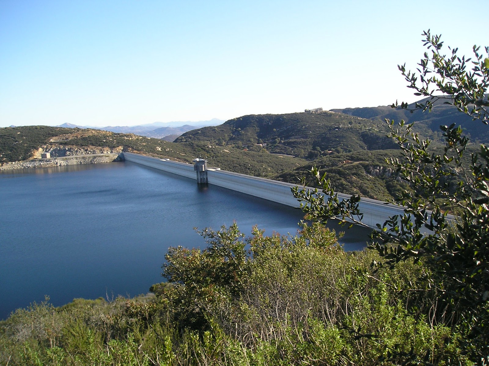
The climb will take you about 1.4 miles up using switchbacks for the most part. Once close to the top, the trail starts to level out with a gentle incline. You can take a couple of alternate hiking paths before you reach the maintenance road, but if you continue on up the trail, you’ll reach a nice little picnic area overlooking Olivenhain Dam and Reservoir. Restrooms are available at this point and farther along at the dam overlook. When you reach the maintenance road, it is decision time. Do you want to go left or to the right? If your goal is to climb Mt. Israel and see the ocean, Catalina Island, San Clemente, and the Coronado Islands, then go right (or West). If your goal is to climb the ridge so you can see both Olivenhain Reservoir and Lake Hodges, and the mountain ranges to the East go left (you can see the mountain range from Mt. Israel as well). Both views are incredible.
Mt. Israel is not mentioned on any of the literature or hiking paths offered by the Olivenhain Water District, so if you’re interested in learning more about that peak, visit www.peakbaggers.com and scroll down to Mt. Israel and press the link. This mountain is ranked 95 out of 100 with 100 being the easiest mountain to climb (Bernardo Mountain is ranked 100 and is just to the East of this hike). Using the Olivenhain Water District trail guide, Mt. Israel is item number 22 on the guide and is called the Elfin Forest Overlook. This excellent little hike has a total 1,346 ft elevation.
We walked along at a casual pace picking different hiking trails as we reached the top. There are two benches and trash cans available at the top for comfort and needs. No restrooms – officially. But views from here to eternity and some stunning ones at that. Naturally, I have to find the tallest rock at the summit to stand on and strike the pose.


At the top, we had a bite to eat, looked at the scenery and using our compass and best guesses, we pointed out different peaks off in the distance. Standing at the summit and using your map and compass, you can have some additional fun figuring out which peak is which. Here are some to find while you’re there. I can’t remember where I found this information, but I read about the author being a Marine and avid hiker. As far as I can tell, the numbers are pretty much spot on. No idea on the distance though.
NORTH:
· Palomar Mountain MN 26 degrees, 25 miles.
· Palomar Mountain MN 26 degrees, 25 miles.
EAST:
· Volcan Mt in Julian MN 65-70, 30 miles;
· North Peak MN 86 degrees, 32 miles;
· Middle Peak MN 90 degrees, 32 miles;
· Cuyamaca Peak MN 93 degrees, 32 miles;
· Woodsen Mountain (Poway) MN 105 degrees, 11 miles;
· Iron Mt MN 113 degrees, 13 miles.
· Volcan Mt in Julian MN 65-70, 30 miles;
· North Peak MN 86 degrees, 32 miles;
· Middle Peak MN 90 degrees, 32 miles;
· Cuyamaca Peak MN 93 degrees, 32 miles;
· Woodsen Mountain (Poway) MN 105 degrees, 11 miles;
· Iron Mt MN 113 degrees, 13 miles.
SOUTHEAST:
· Lyons Peak MN 127 degrees, 34 miles;
· Tecate Mt (on Mexico border) MN 129, 43 miles;
· San Miguel Mt MN 143 degrees, 29 miles
· Lyons Peak MN 127 degrees, 34 miles;
· Tecate Mt (on Mexico border) MN 129, 43 miles;
· San Miguel Mt MN 143 degrees, 29 miles
Mount Whitney (our local Mt Whitney – not “the” Mt Whitney) is the peak with the radio building on it at 313 degrees MN, just across the valley. Paint Mountain (with a house and palm trees on top) is west at 236 MN. On a clear day, the San Bernardino range is visible to the north at 2 degrees MN. This view is looking South to Southeast.

We started our descent off the mountain toward another rest area close to the dam so we could see the expanse of the reservoir and read the historical board how/when the dam was constructed and then we started our trip back. This is such a beautiful site. Until I started planning for this hike, I didn't even know this dam was there. I just love learning more about our wonderful little county.


Taking yet another side trail, we found ourselves walking through the chaparral and along a narrow, winding trail. Birds were flying through the shrubs and we could see coots, ducks and other water fowl in the reservoir. Along the trail we saw deer, raccoon, bird and dog tracks.


We continued taking alternate hiking trails until we reached the way down and started our decent. About a mile down, we took the botanical trail and came back to the trailhead from that direction. This is another well maintained trail and looked like it has been used a lot. It’s a nice, cool walk through the trees and along the creek.


The unimproved creek crossing is a must for a little adventure as you wrap up a very nice 5 mile hike (taking the route we did). Dipping your hot feet into the cool water is a good thing as well.

Let me know what you think.
Be safe, enjoy living and appreciate our lands. ~ Joel
Lat/Long
33° 4' 31'' N; 117° 8' 35'' W
33.075401, -117.143068 (Dec Deg)
486647E 3659655N Zone 11 (UTM)
33.075401, -117.143068 (Dec Deg)
486647E 3659655N Zone 11 (UTM)
No comments:
Post a Comment