Red Hill is a short hike in the Southern part of Anza-Borrego outside of Ocotillo, CA. Note, once you've finished your hike, you must have a cold one at the Lazy Lizard (non-paid ad). It's a fun little place right off the main drag - there's only one main drag....
Anyway, park off the side of the road along Imperial Highway just North of Imperial Highway Monument anywhere you feel safe. It's a short jaunt, but use the wash vs. what we did. Our trip was a bit more "adventurous" if you know what I mean...
Motor called this the landslide shot...not sure what he meant? But (pardon the pun), this was the only way for me to get down. Steeper than it looks.
This area is called the volcano hills for a reason. Here is a small piece of lava that permeates throughout the area.
Once on top of Red Hill, it literally looks like a moonscape. Red lava everywhere and basically a flat top. No benchmark that we could find, but there is a register located at a cairn. Motor is trying to help me find the benchmark, but we came away empty handed.
Location of the register.
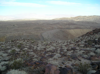
Looking NE (?) over the desert. Didn't use my compass, so it's a best guess.
More of the top.
Coming down off of Red Hill.
If your trip up doesn't look like this, you're in for some fun rock climbing/sliding. This wash takes you all the way to Imperial Highway. That's Red Hill in the background (and it's really red compared to the rest of the local hills.).
Have fun and let me know if you want my track.
Be safe, enjoy living and appreciate our lands. ~ Joel
Directions and Numbers:
I-8 to Ocotillo. Imperial Highway past the Border Patrol Check Point. Stop once you pass a dirt road with the Imperial Highway Monument and can see Red Hill on your left about a mile away. Elevation about 1720 or so with only a few hundred feet ascent. About 2.5 mile round trip.
32° 47' 32'' N; 116° 8' 17'' W
32.792337, -116.13817 (Dec Deg)580698E 3628595N Zone 11 (UTM)


No comments:
Post a Comment